. > ...
the history of Leyton and Leytonstone
from . dot to … dots – with plenty of spaces

the Anglo-Saxon period
5 for an illustration go to http://commons.wikimedia.org/wiki/Image:Lime_tree.jpg
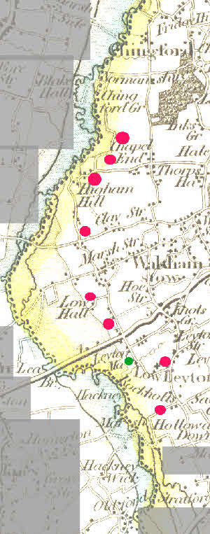
The flooding of the marshes beside the River Lea made them better pasture. Settlements were often located on the nearest dry land to a floodplain 3 . Down the east side of the Lea Valley was a string of manor houses close to and overlooking the Lea Valley but just on higher ground (see the map on the left). Each had land stretching west into the marshes and east to the belt of forest and wasteland which survives today. Ruckholt was the most southerly in what is now Waltham Forest (the others were Leyton Grange, Mark House, Low Hall, Higham Benstede, Chingford St Paul and Chingford Earls). There was also a moated house ‘Godsalves’ by 1547 where Etloe House was later built on Church Road, Leyton 5b. The parish of Wanstead extended to the River Lea, including what became Cann Hall Road. Presumably all these manors exploited their section of the River Lea for hay-meadow, water power, boat transport, fishing, eel-catching and wildfowl.
Hornbeam, oak and beech do relatively well when a wood is grazed, but lime trees do not 4. Lime trees 5 disappeared completely from Epping Forest, and this radical change was completed in the Anglo-Saxon period, presumably the era in which the Forest was fully exploited as wood-pasture. (The Leyton edge of the Forest is now mainly hornbeam with oaks.) >>
By the time Domesday Book was prepared most villages had a parish church at which mass would be said, and baptisms, marriages and burials performed. The foundation of each church must have been instigated or at the very least assisted by the local Anglo-Saxon lord 2 . Parishes in a number of areas have boundaries giving adjacent parishes a piece of each of the types of land available. Leyton stretches from the River Lea through fields to the heath of woods that now form Epping Forest. So do each of its two main manors 6.

